Showing posts sorted by relevance for query permeability. Sort by date Show all posts

Monday, June 16, 2014

Fine grain design - the permeability remedy

Laneway in Langley - flowers, color, and personal touches

Yesterday I walked another small town, this time the village of Langley in Washington State, and found a gem. It reminded me of themes from the book Happy City and what my social planner friend Wendy Sarkissian says about making spaces work well. "We must pay careful – and loving – attention to the fine grain. The divine dwells in the details."

That was true last week in my blog on Brandon where high-density, low income housing so dramatically outshone nearby low-density suburban sprawl. And it was true yesterday in Langley where plants, paintings, murals, and all sorts of personal embellishments adorned laneways, alleys and the walkways between them. More importantly, those adornments were installed and maintained with loving attention by the owners of adjacent shops and residents living nearby.

Walkways need attention - plants, windows and natural surveillance 
Wisely, the town council did not regulate away these informal design details in some regulatory panic. That was wise. It is a step towards the fine grained urban design that will succeed where design guidelines will not. And it looks beautiful. (They were busy too! I waited for ages to take pictures without people walking in the alleyways). People say they don't like alleyways and high density until they see how well it can work.

In her 2012 presentation What's Psychology got to do with NIMBY? Wendy reminds us in order to show residents how it works "we must retrieve and embrace our lost sociological and psychological wisdom about what makes good housing and good neighborhoods."

In Langley lanes were decorated with flowers and windows looked down upon those flower-strewn spaces. Beauty and natural surveillance work better when they go hand in hand.

Decorations, landscaping, clear sightlines and windows - details matter
Skillful attention to the fine grain is precisely why the permeability-is-bad crowd miss the point. They believe more people walking and driving through an area increases crime risks because more potential criminals can access crime opportunities anonymously.

We don't need gated communities to be safe. What places inside Brandon and Langley show is that even places with plenty of flow-through can be made safe with the right kind of density, fine grain design, and locals who care.

Tuesday, April 8, 2014

Cul-de-sacs - crime and controversy


Road design and crime?
A recent email from a planner friend asked about reconfiguring a roadway: "I am working on rightsizing a suburban arterial. There have been some assaults and break ins. There is some speculation as to whether converting it from 6 lanes wide setbacks to 4 lanes with buildings up to the street will change this dynamic"

It made me think of other 6 lane, car-dominated cities. It also brought to mind some environmental criminology (EC) research supporting cul-de-sacs. The EC crowd is generally critical of New Urbanist  designs for grid streets and increased neighborhood permeability.

The New Urbanism version goes like this: If we narrow the streets and avoid wide boulevards to slow car traffic we will encourage a more walkable street. If we use grid designs versus cul de sacs we can better provide walkable locations for people, activate neighborhoods, and make them safer.

The EC version goes like this: Grid layouts increase permeability and let more strangers through and that increases the risk of crime. That's why corner houses have more crime! Cul-de-sacs have less crime than grids for the same reason.

Not exactly.

Environmental criminology and burglary

What most EC studies actually show isn't patterns of crime. They show patterns of burglary. In fact the preponderance of EC studies (at least in the early years) were on burglary and theft versus robbery, interpersonal violence, shootings, gangs or drug crime - the crimes people fear most.

Still, EC's burglary-obsession should not detract from the point. Tantalizing answers emerge elsewhere; within the library of Problem Oriented Policing projects.

The POP library lists hundreds of projects on a wide variety of crimes. They describe both physical place-based prevention combined with social prevention. In most cases it was not physical tactics - design-out-crime - that did the trick. It was the  holistic ones that did, tactics that carefully considered context first and design impact second.

Curvilinear suburban road design - where do you walk? 
Interestingly, one EC reviewer says this about context:

"Today, interior spaces within the home are dominant, and are commonly filled with electronic multimedia technologies and entertainment (also providing more opportunities for crime). The interior is now defined as the ‘leisure action space’ for both adults and children. This has led to exterior/public spaces being less used and this withdrawal has led to them being re-labeled and re-defined, often as ‘dangerous’ spaces."

Exterior spaces less used and defined as dangerous? If ever there was ever a context for New Urbanism, there it is!

Good design 

Good urban design should make exterior spaces less vacant, boring and unfriendly. It should create interesting walkable streets, places to go within walking distance, and a lively outdoors with ample social spaces for diverse people to socialize.

Urban guru Enrico Penalosa, and former mayor of Bogota during its widely-acclaimed redevelopment, finishes the thought: "The most dynamic economies of the twentieth century produced the most miserable cities of all. I'm talking about the U.S. of course - Atlanta, Phoenix, Miami, cities totally dominated by private cars."


"The most miserable cities are dominated by cars" - Penalosa 

Tuesday, March 14, 2017

Spaces between buildings - Brisbane laneways

Unattractive laneways attract undesirable behaviors

by Mateja Mihinjac

Towards the end of the past Century, a gruesome downtown rape shocked Brisbane, Australia. The incident occurred at 9 am in a laneway surrounded by the pedestrian corridor of the busiest spot in Brisbane, the outdoor Queen Street Mall.

This horrific incident went unnoticed by the city workers rushing to their offices. The victim, a young woman, remained helpless in the shadows of the bland gray facades of the surrounding buildings.

FAST FORWARD 20 YEARS

Today numerous Brisbane laneways have undergone a remarkable visual transformation aiming to imitate similar successes in Melbourne and Sydney.

Burnett Lane is Brisbane’s oldest laneway with a dark history of a prison exercise yard during the early penal colony days.

Burnett Lane buildings feature its long history

It was the first to undergo rejuvenation. The 600-foot laneway now boasts creative lighting and artwork that characterize its cultural and historical identity. It has a few small restaurants, cafes and bars, the largest vinyl record store in the Southern Hemisphere and a wine bar with late evening hours.

Winn Lane and Baker Lane, situated in the middle of the night entertainment district, also offer a mix of diverse opportunities in one place. They host day and night cafes, eateries, service shops and small retail shops that attract Brisbane’s artisan community.


Eagle Lane cafes
Once a forgotten place surrounded by tall buildings, Eagle Lane now offers a bar and a café, street parties, artistic installations and live music with pop-up gigs in the evening hours. It has become a popular post-work venue for city workers in the financial district.

IF YOU BUILD IT, THEY WON’T COME?

More than a dozen other laneways across Brisbane’s CBD have sprouted since the City’s Vibrant Laneways program was introduced in 2006, and more are pending. However, according to critics the program leaves much to be desired since laneway culture in the city has yet to truly flourish.

They suggest that the City’s domination of the Vibrant Laneways program resulted in mechanically built laneways that failed to evolve over time. Instead, as predicted by SafeGrowth theory, they recommend the laneways should grow organically as a product of the creative and entrepreneurial activities of locals whereby the city assumes a cooperative rather than the leading role.

Relaxed dining in Winn Lane 
Confirming this idea is that fact the laneways attracting most people in Brisbane are those able to capitalize on their creative and economic potential to develop imaginative places. Elements that promote their vitality include permeability, accessibility, the absence of vehicular traffic and a positive image.

Truly vibrant laneways convince people to stop and linger, which in turn activates the area and reduces the potential for undesirable activities like serious crime.

Combining cafes, dining, retail and services in Winn Lane

SAFE LANEWAYS

For laneways to be safe, they need to move away from what Woodhouse describes as “forgotten space within cities, trapped in the dark and quiet spaces” offering nothing more than pedestrian thoroughfare and service delivery access.

Instead, as Carmichael claims, with collaboration between business planners, interest groups, and local governments, these precious micro-spaces can facilitate social interaction, promote safety and evolve into assets and anchors for community life in the 21st Century.

Friday, November 24, 2023

A bird's-eye view of safety - Urban morphology and crime

Astronaut Tim Kopra took this night photo of Chicago from space. Beginning in the 1920s, Chicago became a center of research into morphology as a crime factor - photo courtesy NASA


by Gregory Saville

The promise of scientific discoveries never guarantees positive results. That is up to us and the wisdom of our choices. But without rational thinking, data and evidence, and decent research on the problems of our day, we cannot expect to reap the rewards that proliferate in the sciences. This especially applies for city building and crime prevention.

That brings me to what social geographers call urban morphology. Urban morphology is the scientific study of the macro geometry and physical form of cities and towns, such as street patterns, land uses, and population densities – basically modern urban land use planning. It was during my university classes in urban morphology that I first learned why architects and urban planners think so differently. 

An architect might design building windows facing the street to improve natural surveillance and decrease crime. But a traffic engineer might design a wide, one-way street to speed vehicles from one region of the city to another. Speeding cars make a street inhospitable and unwalkable, in which case no one bothers to look outside. So much for natural surveillance. 

Many times I have been asked to look at street crime and noted empty sidewalks, loud vehicle noise from speeding cars, and high vehicle speeds on a wide, one-way street. Morphology matters and recent criminological research confirms it. 


The traditional suburban cul de sac - Photo by Michael Tuszynski on Unsplash


CUL-DE-SACS

Take the cul de sac. Some criminologists claim that cul de sacs are the safest places to live because we get to know our neighbors which leads to territorial control and that cuts crime. Having lived on a cul de sac, I often questioned those assumptions. Were those assumptions actually based on scientific data or were they just a pocketful of anecdotes? 

In environmental criminology, I learned that cul de sacs were places of lower crime due to limited permeability, controlled access, and increased territoriality. Some studies supported that hypothesis.

Then new research challenged that hypothesis. One South Korean study showed how cultural factors can exacerbate, or mitigate cul de sac risks. Another study by Mateja Mihinjac in her criminology graduate research also challenged the cul-de-sac-is-good hypothesis. Her research indicated they had no impact. All this, of course, is how science is supposed to proceed:

Hypotheses are tested --> old theories fall --> new theories emerge.

Then I read the work of civil engineer, Charles Marohn, someone with decades of experience designing roads and streets. 

Marohn and his colleagues examined the fiscal side of street designs, including cul de sacs. They looked at the street engineering of cul de sacs and compared the fiscal costs of construction, maintenance, replacement, asphalt, and extruded curb costs, with other types of streets. The results were not encouraging. 


Cul de sacs were envisioned as safe areas
- Photo by Stephen Andrews on Unsplash

Another urban planner re-examined Marohn’s hypotheses and studied cul de sac street design costs in his own city. His research too was shocking. 

It turns out that cul de sacs make no fiscal sense. They are expensive to construct and difficult to maintain. Cities end up in the red when they attempt to cover costs. Tax revenue from residents does not come close to paying for cul de sacs. Costs for maintaining cul de sacs balloon as they age and they will eventually need huge property tax increases or federal subsidies – neither of which is likely. So not only are cul de sacs not exactly the crime panacea first thought, they are also fiscally unsustainable.


STRONG TOWNS MOVEMENT

This research is a product of the Strong Towns movement. Strong Towns researchers raise all sorts of important morphology questions that pertain to crime. For example, what about all the excessive parking lots in cities and their contribution to safety, crime, and fiscal sustainability? 


Many modern cities have excessive parking, mostly unused


In Dallas, Texas 25% of the entire downtown land use is for parking cars, often the same empty parking lots where people are assaulted and cars are easily stolen. When Strong Town researchers dug into the municipal costs to cover car parking, the result was alarming. These are costs that could be better spent on housing the homeless, responding to toxic street drugs, or better public transit. 

The Strong Town advocates have some intriguing design answers. Installing curbside patios to replace downtown parking spots is one type of repurposing that can help. For example, Toronto instituted curbside patios and found they produce 49 times more money than the street parking spots they replaced  – again, money that might be tapped for better livability results.
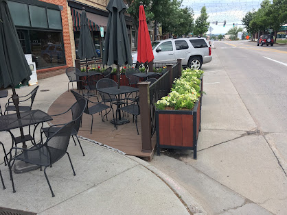

Street patios are inexpensive, bring more fiscal returns than parking spots,
and provide a popular livability option 

Charles Marohn is the president of the Strong Town movement and his book, The Confessions of a Recovering Engineer is a must for those interested in city design and SafeGrowth.

It emphasizes the role of scientific research and evidence in urban planning and design if we are to reap the kinds of successes in crime prevention that we see in other branches of science. 


Wednesday, July 30, 2014

The wall and the window - Mystery in space


Reading studies on crime and place I was recently struck by a mystery among environmental criminology researchers who study CPTED, particularly territoriality (the wall) and natural surveillance (the window).

It brought to mind other concept errors in crime and place research, specifically crime generators, permeability, cul de sacs, and the Achilles Heel within routine activity theory. This time the mystery cycles around guardianship.

Here’s the storyline…

Researchers regale the power of natural surveillance to enhance guardianship. Guardianship presumes to increase the risk that offenders will be seen and caught. Natural surveillance has appeal because you can observe whether a space has lighting, sightlines and nearby windows. Because surveillance presumably will produce more preventive action by residents (or reluctance by offenders to show up), you can then measure what happens.

EYES ON THE STREET

Natural surveillance assumes that people who see something out of place will act, thereby providing guardianship. Thus it is “real”. It's an assumption borne out nicely in low-crime, upper income areas but not so much in lower-income, high crime areas where residents are afraid to step outdoors and when they do their presence doesn’t deter anything.

Fences, windows and flowers creating territorial control on a San Diego public walkway 
On the other hand researchers question the power of territoriality to enhance guardianship, mainly because they say territoriality lacks "definitional rigor" and it isn’t “real”. Floral decorations or landscaping…is that it? Maybe it’s access control, walls and gates? Even worse, territoriality varies from place to place. Horrors!

They suggest natural surveillance is preferable to territoriality because it seems more measurable. That’s how they solve the mystery of territoriality. They ignore or downplay it, label it with   definitional problems and claim it isn't "real".

THE SECRET

Historian Howard Zinn warns us about such storylines: “Realism is seductive because once you have accepted the reasonable notion that you should base your actions on reality, you are too often led to accept without much questioning someone else’s version of what that reality is.”

Consider this: If territoriality isn’t real, then how is guardianship any better? And why shouldn’t territoriality vary from place to place?“The real world,” says Zinn, “is infinitely complex and constantly changing.”

Perhaps social science research methods are too simplistic to tell us anything complex? Perhaps it is guardianship that has a definitional problem, especially given territoriality’s much longer provenance.

What provenance? Consider Jane Jacobs’ Death and Life of Great American Cities, Robert Ardry’s The Territorial Imperative, Edward Hall’s The Hidden Dimension, Oscar Newman's Defensible Space, and Alice Coleman's Utopia on Trial. And all that territorial work still continues today such as Kevin Leydon’s study on walkability and social capital.

MYSTERY SOLVED

CPTED practitioners seldom complain about such things because context always comes first.

For example in SafeGrowth practitioners and residents use a Risk Assessment Matrix for surveys, safety audits, site visits, and asset maps. Together they create a profile of the neighborhood and what residents feel about it. Only then do they determine to what extent designs enhance territoriality.

Overcoming "definitional rigor"?

Simple: Ask the residents and work with them to discover what they feel enhances their territorial control, a method known as action research and action learning. Mystery solved.


Monday, May 23, 2016

Edgewater - I am not the Lizard King


Urban planner Jeff Speck equates dense, well-built and walkable cities with economic growth, environmental resilience and a safer, more livable life. In his book Walkable City he provides plenty of evidence to prove it.

This week I visited Edgewater, a small city (population 5,000) enveloped by the urban fabric that is Metro Denver. It is medium income, has diverse ethnic groups and comprises mixed residential with a commercial street of a few blocks. It is close to what Speck describes.

Edgewater street furniture, walkable streets, and human scale
From a city map it is undistinguished from surrounding Denver suburbs, until you look at its crime.

Orange and red areas showing higher crime areas, Edgewater shows lower crime rates in yellow - crime map from city-data.com
As the map above shows, except for a few crimes, its crime rate is far below surrounding neighborhoods particularly one crime hotspot to the north.

The question is why? Urban design is not the only reason, but as I’ve shown in blogs on permeability in Langley and High Line Park in Manhattan, it can matter a great deal.

PLANNING AND URBAN DESIGN

Planning students learn about early movements to plan cities. One history textbook that some read is Land Use Planning from 1959. A phrase in that book is instructive:
“The unit of design in New Towns is no longer each separate lot, street or building; it is the whole community; a co-ordinated entity…beauty as well as convenience is produced by the rational relations of the individual parts…”
Unfortunately that philosophy did not survive. Instead, land hungry developers gobbled up huge swaths of city edges to build suburban sprawl, regional shopping malls, supersized box stores and pedestrian-hostile commercial strips.

The idea of planned and walkable neighborhoods was lost. But not, apparently, in Edgewater.

Murals, bicycle racks, and even-grade sidewalk curbs for handicap accessibility 
EDGEWATER

Edgewater clearly works - even the quiet afternoon when I visited had walkers for whom I had to wait before taking photos. There are no more cops here than elsewhere, yet people feel safe and comfortable while walking. Why does it work?

Speck says there are four ingredients to walkability: a reason to walk, a safe walk, a comfortable walk and something interesting to see and do. Edgewater seems to capture most of them.

The residential streets are narrow and tree-lined. Most of them are within a 15 minute walk of the mini-downtown. That downtown is neatly streetscaped and has diverse uses such as restaurants, coffee-shops, a local pub, and other amenities that provide locals a reason to come here. The downtown has only 4 blocks and they are short, about 75 feet each.

Color, flowers and sculptures - Edgewater sidewalk 

Flowers sponsored by students from a local 4th Grade class
Shops are also easily walkable - the distance of one store to another, door-to-door, is no more than 15 feet. Street flower pots are planted by local school children, murals cover blank walls and street furniture, like angled benches, provides both interest and comfort.

THE ALTERNATIVE - THE LIZARD KING

Only a few blocks outside of Edgewater, in yet another pedestrian-hostile commercial strip, the automobile remerges as King. You can almost hear it holler: I am the Lizard King, I can do anything. (Apologies to Jim Morrison).

Just outside Edgewater, hostility awaits the walker - Cars are the Lizard King 
Here intersections are ugly and vast, speeds are high and walkers are treated like invaders. Such places force people to stay inside their car and avoid all social contact except during moments of road rage.

Speck says: "The worst idea we’ve ever had was suburban sprawl…the reorganization and creation of the landscape around the requirement for automobile use." We will probably need autos for a long time to come, but we need walkability even more. Let's get our priorities right.